Sunday, September 30, 2012

Road Trip 2012: Saturday 9/29

Still camped in Lyndsay Belt's driveway in Boise, Idaho

I got to meet Lyndsay's boyfriend today.  Mike is a firefighter for the US Forest Service.  He has been stationed out of town and just got back home late last night.  Mike and Lyndsay live together and are a great young couple to spend time with.  They are proud and eager to show off their adopted city of Boise.

They took me to downtown Boise today to visit the Farmer's market.  What a great time.  It was T-shirt weather and the place was bustling with people, sights, sounds, and aromas.  We spent a couple hours there and ended up buying some grass fed beef and fresh bell peppers for dinner.


The market is just a block or so from the Idaho State Capital Building, so we toured that as well.  The central part of the capital building was built between 1905 and 1912.  Since that time, additions have been built.


View from the upper level looking up Capital Boulevard.

We ate lunch downtown at The Bittercreek Alehouse in the outside seating area, people watched, and sampled some local beers.  On the way back home, we stopped at the Boise Depot.  The building was last used as a passenger train depot in 1997, and is now operated by the Boise Parks and Recreation Department as a historical site and public meeting space.  The depot sets on a hill at the opposite end of Capital Boulevard and looks downtown toward the capital building.


We ended the evening grilling dinner on the back deck and watching Boise State football on TV.  Zoey loves playing with Lyndsay and Mike.  They also have a dog, a wonderful older one named Nova.  Nova dismisses Zoey as too youthful and foolish.  :-)


A full moon was rising when I went to bed.


More adventures Sunday.........

Saturday, September 29, 2012

Road Trip 2012: Friday 9/28

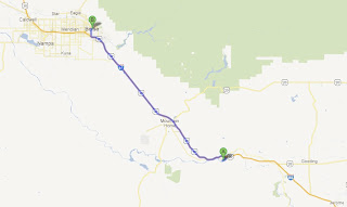
86 miles, camped in the driveway of Lyndsay Belt in Boise, Idaho.  Lyndsay is a former student of mine at Potsdam High School.


Zoey and I spent a leisurely morning at Three Island Crossing State Park.  The park was less than a third full (although it was booked full for the coming weekend) so there was lots of walking space, as well as several trails.  One of the trails was along the Snake River at the Oregon Trail crossing.  We hiked about three miles, and caught a great sunrise over the Snake River.

Sunrise over the Snake River

Looking downstream at one of the three islands.

Display board explaining the dangerous crossing.

I stopped at the Oregon Trail Interpretive Center, which is located in the park, and spent an hour looking over the displays.

Oregon Trail Interpretive Center.
I arrived at the Boise Interagency Dispatch Center about 2:00.  Lyndsay has a seasonal job with the BLM (Bureau of Land Management) working at the Boise Dispatch Center.  The center is called Interagency because it dispatches fire control teams for both the BLM and the US Forest Service.  Because of the extremely dry summer, the Dispatch Center has been very active.

Lyndsay at her dispatch station.

Dispatch Office


Fire Engine Pumpers

Burned BLM grasslands

After a tour on the Dispatch Center, we went to Lyndsay's home and I set up camp in the driveway.  We later walked to a nearby restaurant for dinner.  The weather was warm, so we took the dogs with us, and ate at an outside table.

On Saturday Lyndsay is taking me to the Boise Farmers market.

Friday, September 28, 2012

Road Trip 2012: Thursday 9/27

141 miles, camped at Three Island Crossing State Park, at Glenns Ferry, Idaho.  This park is one of the most beautiful state parks I have ever stayed at.  There are huge green lawns with paved roads and wide spacing between sites.  On top of that, on Monday through Thursday, the rate is half for those 62 or over.  So a night here cost me $11.66 for the best camping spot on the entire trip so far.

Arco, Idaho to Three Island Crossing State Park, Glenns Ferry, Idaho

Site 31, Three Island Crossing State Park

Squirrel patrol.  None will get near us.  :-))

I returned to Craters of the Moon this morning.  There were two more hikes I wanted to take.  One was to take the Tree Molds Trail.  This trail leads to an area where molten lava flows encased trees and then hardened.  The molds remain after the wood burned and rotted away.  There were several cylindrical molds formed from standing trees, and a couple examples of fallen trees that left the bark imprints.

Trail to the tree molds.  A lava field is visible on the right.

Mold from a standing tree.

Mold from a fallen tree.

Bark imprint of a fallen tree.

The second trail was to the caves area.  The caves are formed from lava tubes.  When molten lava is flowing, as it did here about 2,100 years ago, the top of the lava flow starts to cool and form a crust.  Eventually the molten lava drains away, leaving a tube or cave.  The tubes can be any size, ranging from inches to many feet.  The 50 feet wide, 30 feet high and 800 feet long Indian Tunnel cave is the largest of the three accessible at Craters of the Moon.  I entered one for 40 or 50 feet, but I didn't have a flashlight, so that was as far as I went.  I did make a short video with my iPhone.

Trail to the caves.  You can just see my camper in the distance.

Farther along the trail.  Just a sea of bare rock.

Here is a one minute video clip I took with my iPhone.


Zoey and I left Craters of the Moon about noon, and arrived at Three Island Crossing at 2:30.  This is a beautiful park.  I set up camp, and we went for a walk.  I happened across another truck camper couple, George and Betty, and I stopped to visit because they were further from home than I.  They had Rhode Island plates.  George was meeting his son in northern Idaho in a couple of weeks to go elk hunting.  Betty was going to fly home then, while George and his son would drive the truck back to Rhode Island after hunting.  I discovered that Betty was a retired Biology teacher.  We sat for an hour or so, sharing wine and conversation about teaching, truck campers, and traveling.  In fact, they were at Craters of the Moon on Wednesday, one of the same days I was there.  I'm sure I remember seeing their truck there.  It was a great way to end the day.

Friday morning I want to explore the Oregon Trail Interpretive Center and hike some of the trails with Zoey.  In the afternoon I head for Boise to meet former student Lyndsay Belt.  She is working as a fire dispatcher for the BLM this summer.  Stay tuned...........

Thursday, September 27, 2012

Road Trip 2012: Wednesday 9/26

50 miles, and still camped in Arco, Idaho, but this time at Mountain View Campground.

Campsite at Mountain View Campground.

Checking out Craters of the Moon National Monument and Preserve was today's project.  The monument is only 20 miles from Arco, so it was a short drive.

Zoey is thinking, "I have to pose again.  Is this ever going to end?"

We arrived there about 9:00, and the parking lots were mostly empty.  The scenery is surreal!!  I can see why it was though to resemble the moon.  The difference is that most of the moon's surface has been created by meteor impacts, while this area was created by volcanic activity.  The term "Craters of the Moon" was coined by a geologist in 1923, and the name stuck.  The vast volumes of lava issued from a series of volcanos along the Snake River Plain collectively known as the "Great Rift."  The volcanic activity began about 15,000 years ago, with the most recent activity ending 2,000 years ago.  Vegetation has started to populate areas of the landscape, while other areas are too dry and windswept to show any plant life, even after 2,000 years.


Dwarf Buckwheat on a cinder slope.

Dwarf Buckwheat

Vast lava field as far as you can see.

There is a seven mile drivable loop road with several parking lots for viewpoints and trails.  There are very strict regulations about only hiking on established trails because of the fragility of some of the rock.  I ended up hiking about five miles on various trails.

Hiking up a cinder cone.


Looking down into the vent of a cinder cone.

Collapsed lava tube.

Trail in a lava field.

By 2:00 I was tired, so I headed back to Arco and camped at Mountain View Campground.  I met a retired High School Principal from California who was camping near me.  We spent some time commiserating about the "teach to the test" state of education now.   We are both hoping the pendulum will swing back at some point.

I plan to finish exploring Craters National Monument on Thursday.  I'm not sure where I'm going to spend Thursday night yet, but I need to be in Boise, Idaho on Friday afternoon..........


Wednesday, September 26, 2012

Road Trip 2012: Tuesday 9/25

322 miles, and camped at the KOA in Arco, Idaho.


Cody, Wyoming to Arco, Idaho
We got an early start today and left the campground in Cody, Wyoming about 7:00.  I wasn't really sure where I would end up tonight but I wanted to head in the direction of Craters of the Moon National Monument in eastern Idaho.  The most direct and picturesque route was through Yellowstone National Park.  I have visited Yellowstone several times, seeing small sections of it each time.  There is so much there to see and experience.  This route would take me past some spots I haven't seen since 1978 (OMG, that's 34 years ago) when Kathy and I took our three sons across the country when they were five, six, and eight.  In fact, here is a picture from that trip taken in Teton National Park, just a few miles south of Yellowstone.  I had considered driving by the Tetons on this trip, but other travelers I've met told me that the smoke from the western forest fires was so great that it was hard to enjoy, much less see the mountains.


Yellowstone is an eclectic mix of scenes, ecology, and geology.  There is so much to see and learn, you need to spend days here to capture it.  I'll just add some photos of today's trip and let the captions explain them.  The photos are in chronologic order as I traveled today.

Buffalo Bill Reservoir

Exercise break in the Shoshone National Forest where dogs are allowed on the trails.

Fall colors in the Shoshone National Forest

East Entrance of Yellowstone National Park.

Sylvan Lake in Yellowstone National Park.

Lower Falls of the Yellowstone River in the Grand Canyon of the Yellowstone.

Upper Falls of the Yellowstone River in the Grand Canyon of the Yellowstone.

Forest regrowth from the extensive 1988 forest fires.

Steam vent in the Norris Geyser Basin

Hot mineral pool in the Norris Geyser Basin


Ten second video of a steam vent.

Madison River near the West Entrance of Yellowstone National Park.

On Wednesday Zoey and I are off to explore Craters of the Moon National Monument.